Europe 2010 - The Alta Via 2, Italian Dolomites
24 Jul - 6 Aug 2010
All content copyright © Ashley Burke 2010. Not to be copied, duplicated or used for any purpose without permission.
Europe 2010 - The Alta Via 2, Italian Dolomites 24 Jul - 6 Aug 2010
All content copyright © Ashley Burke 2010. Not to be copied, duplicated or used for any purpose without permission. |
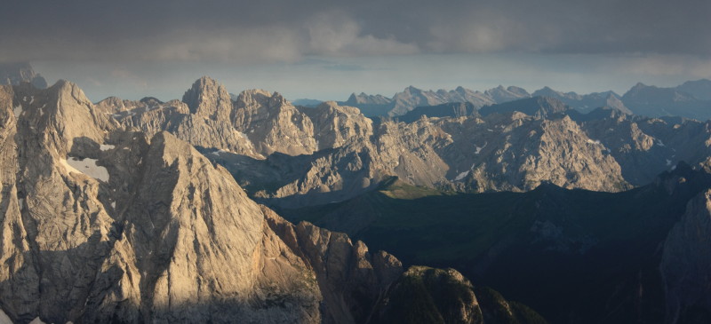
Evening views from Capanna Fassa on the summit of Piz Boè in the Sella group, AV2 Stage 2
Contents
The Alta Via 2 (AV2) is a famous long distance hiking route through the Italian Dolomites. The walk runs roughly from north to south, starting in Brixen (Bressanone) in South Tirol and ending in Feltre. In the summer of 2010 I did the walk over a 13 day period, although this could easily be shortened to around 10 days. The Dolomites themselves may be divided into mountain groups, clusters of peaks separated by deep valleys and alpine passes. The Alta Via 2 passes through several well known mountain groups and passes of the Italian Dolomites including the Puez-Odle group, Gardena Pass, the Sella group, Marmolada, the Pala di San Martino and finally the Feltre Dolomites.
Scenically the Italian Dolomites are stunning, the skyline is crammed with jagged peaks of limestone and rugged crags, the mountain scenery is equal to or surpasses in grandeur almost any mountains anywhere. Regretably though, the Dolomites have seen a great deal of development by humans, and the landscape is far from pristine. Though the countryside surrounding the clusters of rugged peaks is dotted with beautiful Italian and Tyrolean villages and their medieval chuch spires, the landscape has also suffered the blight of ski fields, cable cars, chair lifts, roads, car parks and tourist resorts. The Alta Via 2 includes some walking through ski piste, scarred landscape that is unavoidable, the price a walker must pay for access to the spectacular clusters of mountains that are the backdrop to popular ski areas.
Throughout the year the mountains are enjoyed by all sorts of people and every mountain sport imaginable is pursued here, from skiing to hiking, rock climbing, mountain biking and paragliding. The Alta Via 2 is one of many routes through the Dolomites and a great way to gain access to this spectacular area.
We did the walk in late July and early August 2010, immediately after completing the Slovenian High Route. Compared to the Slovenian Alps the peaks of the Dolomites are higher and in some ways more spectacular and photogenic. However the actual walking grade of the Alta Via 2 is overall less demanding than the most challenging stages of the Slovenian High Route. Whereas the Slovenian High Route scales the highest and most difficult peaks as part of the main route, the Alta Via 2 is more moderate in nature, it serves as a route through the mountains rather than a route over the mountains. Some of the highlights of the Alta Via 2 are done as variants or deviations from the main route, rather than as part of the main route itself.
We were fortunate enough to have relatively stable weather in the summer of 2010, but the Italian Dolomites were notably wetter than Slovenia, with afternoon thunderstorms and wet spells being more frequent.
I hiked the Alta Via 2 with the assistance of the Cicerone Guide "Treks in the Dolomites, Alta Vie 1 and 2". This guide book was not up to the same very high standard as the Cicerone Guide "Trekking in Slovenia" that we had used in Slovenia immediately preceding the AV2. "Treks in the Dolomites" has some factual errors and is not as well laid out or as easy to follow as the Slovenia trekking guide. It is, however, very useful for trip planning, and in particular for obtaining advance information of what to expect from the various huts and other accommodation on the way. Compared to the Slovenia guide, "Treks in the Dolomites" slightly overstated the level of difficulty of some of the sections of the walk.
The guide book describes the Alta Via 2 in four stages of about 3 days per stage. This web site is organised into the same four sections as the Cicerone Guide.
More than compensating for any deficiencies in the guide book was the outstanding quality of the topographic maps available of the area. By far the best maps of the Italian Dolomites are the 1:25000 topographic maps produced by Tabacco. Not only are these maps visually beautiful but the level of accuracy and detail is splendid, the colouring and shading makes the relief stand out and the maps easy to read, and at a scale of 1:25000 the maps alone have sufficient detail that one could conceivably walk the Alta Via 2 using maps alone and no guide book. Below are the sheets needed for the AV2
| 030 | Bressannone / Brixen, Val Di Funes / Villnöss |
| 07 | Alta Badia Arabba - Marmolada |
| 015 | Marmolada - Pelmo Civetta - Moiazza |
| 022 | Pale do San Martino |
| 023 | Alpi Feltrine Le Vette-Cimònega |
As is the case throughout the European Alps, the standard form of accommodation for the mountain walker is the mountain hut. In Italy these huts are more like mini hotels, with a restaurant, a bar, and a choice of dormitory style accommodation or rooms with 2 or 4 beds. Often the huts are located at high vantage points in spectacular settings. For example, Capanna Fassa is a relatively small hut perched right on top of the summit of Piz Boè, the highest peak in the Sella Massif and a short one hour detour from the Alta Via 2. There are many other huts in spectacular high locations on the Alta Via 2. By contrast, there few camp grounds along the route of the AV2 and those few lie deep in the valleys, and during the summer are crowded with family groups and their pets. There are enough mountain huts on the AV2 that you are never more than a few hours walk from the next hut, so you are free to choose how long or how short each day's hiking will be.
All the mountain huts are also restaurants and many of these are extremely popular with day trippers duing the summer. The range of food available in these restaurants varies considerably from hut to hut, depending on whether the hut is accessible by road or cable car, and on to what extent the hut is a popular dining place with the locals. I prefer to cook my own food on a stove while trekking, but in Italy this is not the norm, and most of the time I ordered food from the restaurant instead of cooking my own.
Gaining access to supermarkets for restocking our packs with food was a little problematic, as detours off the AV2 are required if you want to get to a village large enough to have a supermarket. Generally I found it better simply to rely on the restaurant style food available in the huts, and not to bother trying to self cater.
Despite high rainfall, the geology of the Italian Dolomites is predominantly limestone and this means surface water is relatively hard to come by. Having said this, free flowing water is much easier to find in the Italian Dolomites than Slovenia, and most of the time I had little trouble finding small streams, waterfalls, watertroughs or pipes where fresh water was available.
Below are links to photos and notes from each stage of the walk. These stages are those in the Cicerone Guide "Treks in the Dolomites, Alta Vie 1 and 2", which describes the Alta Via 2 in four stages of approximately 3 days each. This web site is organised in the same 4 stages as the Cicerone Guide.
| Stage 1 | 24 - 26 Jul 2010 | Bressanone (Brixen) to Passo Gardena (Grödner Joch) |
| Stage 2 | 27 - 29 Jul 2010 | Passo Gardena (Grödner Joch) to Passo di San Pelegrino |
| Stage 3 | 30 Jul - 3 Aug 2010 | Passo di San Pelegrino to Passo Cereda |
| Stage 4 | 3 - 6 Aug 2010 | Passo Cereda to Feltre |
All content copyright © Ashley Burke 2010. Not to be copied, duplicated or used for any purpose without permission. Page created 5 Oct 2010, last updated 5 Oct 2010. |