Navigation Tutorial
Lesson 1 - Map Reading
All content copyright © Ashley Burke 2008. Not to be copied, duplicated or used for any purpose without permission.
Navigation Tutorial Lesson 1 - Map Reading
All content copyright © Ashley Burke 2008. Not to be copied, duplicated or used for any purpose without permission. |
Navigation course by Ashley Burke
3. Other Natural Features on the Map
So far we have discussed contour lines and the features that these lines depict on the map. There are other natural and man made features on the map that are depicted in various ways. The map legend will indicate what these features are. In this section I'll discuss two common natural features on the map, these being water courses and vegetation types. I'll discuss these because there is often more information that you can glean from studying these features on the map than a cursory glance at the map and its legend would reveal. Much of this information is specific to the Blue Mountains, near Sydney, Australia, but the material can usefully be applied to other areas as well.
A watercourse can be considered perennial or non-perennial. A perennial one is one which flows, or at least contains water, all year. It is considered a permanent source of water. A non-perennial or intermittent watercourse is a stream which only flows at certain times of year or only after rain. On New South Wales maps, perennial watercourses are marked with heavy blue lines. Fainter blue lines are used to mark non-perennial watercourses.
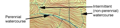
Fig 3.1
Don't always rely on the map as being authoritative on whether a creek will be flowing or not. Just because the map marks a creek with a solid blue line doesn't mean there is always water along its entire length during drought or dry summer seasons. In the Blue Mountains, the likelihood of finding water in a creek will depend on a variety of factors such as:
| Direction of water flow | Streams that flow southwards and eastwards are more likely to have water than streams flowing northwards and westwards. |
| Altitude of headwaters | The higher the altitude of the headwaters relative to the surrounding country, the more likely the creek will contain water. |
| Geology of headwaters | Streams that originate in basalt caps and flow down into sandstone gorges are more likely to contain permanent water. See the Blue Mountains geology section for more information. |
| Depth of the gorge | Creeks that form deep and narrow gorges are more likely to hold water than wide shallow valleys |
| Presence of swamps | Swamps are like sponges that act as repositories and filters of water. Creeks that have swamps in their headwaters are more likely to have good water downstream of these swamps than creeks with no swamps in their headwaters. |
On New South Wales maps, waterfalls may be marked with blue bars along the watercourse as shown in Fig 3.2.
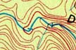
Fig 3.2
If the map doesn't mark waterfalls in this way, then that doesn't mean that there are no waterfalls on the creek. Often waterfalls exist that are not marked as such on the map. In these cases you may be able to infer their existence by examining where the contours cross the watercourse. If contours are close together in a region of creek, then that region of creek is more likely to contain waterfalls. A telltale sign on the map is a flat section of creek followed by a short steep section, followed by a flat section. In this case the short steep section is likely to contain a waterfall. Fig 3.3 shows an example.
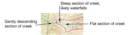
Fig 3.3
Topographic maps will usually include colouring that indicates the vegetation types likely to be encountered over an area of a map. The extent and accuracy of these colourings varies depending on the publisher of the map and you should consult the map key for information on the types of vegetation that are represented. Knowing the type of vegetation you will encounter on your trip is an important component of trip planning, especially when planning off-track walking. These plans need to take into account how dense the scrub is that you will have to walk through, the likelihood of finding camp sites in a given area, the amount of protection the vegetation will provide from the elements and so on. Knowing such factors in advance helps you plan a trip of an appropriate length and level of difficulty for your group. In the absence of first hand experience of actually having been there, your map can be used as a source of this necessary information.
Characteristics of the vegetation and how it is represented on the map varies from region to region, but the following general statements can be made about New South Wales topographic maps, particularly those of the Blue Mountains.
Web page created 12 Jul 2008, last updated 12 Jul 2008. All content copyright © Ashley Burke 2008. Not to be copied, duplicated or used for any purpose without permission. |
